Geo::OGR::DataSource Class Reference
A source and/or storage of vector data layers. More...
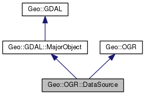
 Inheritance diagram for Geo::OGR::DataSource:
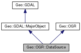
 Collaboration diagram for Geo::OGR::DataSource:
Public Member Functions | |
| public list | Capabilities () |
| public method | CommitTransaction () |
| public Geo::OGR::Layer | CopyLayer (scalar layer, scalar name, hashref options=undef) |
| public Geo::OGR::Layer | CreateLayer (hash params) |
| Create a new layer into this data source. More... | |
| public method | DeleteLayer (scalar name) |
| public Geo::OGR::Layer | ExecuteSQL (scalar statement, scalar geom=undef, scalar dialect="") |
| public method | FlushCache () |
| public Geo::OGR::Driver | GetDriver () |
| public Geo::OGR::Layer | GetLayer (scalar name) |
| public list | GetLayerNames () |
| public scalar | GetName () |
| public method | GetStyleTable () |
| public Geo::OGR::DataSource | Open (scalar name, scalar update=0) |
| public Geo::OGR::DataSource | OpenShared (scalar name, scalar update=0) |
| public method | ReleaseResultSet (scalar layer) |
| public method | RollbackTransaction () |
| public method | SetStyleTable () |
| public method | StartTransaction () |
| public scalar | TestCapability (scalar cap) |
| public method | new () |
 Public Member Functions inherited from Geo::GDAL::MajorObject Public Member Functions inherited from Geo::GDAL::MajorObject | |
| public scalar | Description (scalar description) |
| public method | Domains () |
| public scalar | GetDescription () |
| public hash reference | GetMetadata (scalar domain="") |
| public method | GetMetadataDomainList () |
| public hash reference | Metadata (hashref metadata=undef, scalar domain= '') |
| public method | SetDescription (scalar NewDesc) |
| public method | SetMetadata (hashref metadata, scalar domain="") |
 Public Member Functions inherited from Geo::GDAL Public Member Functions inherited from Geo::GDAL | |
| public list | AccessTypes () |
| public Geo::GDAL::Dataset | AutoCreateWarpedVRT (Geo::GDAL::Dataset src, Geo::OSR::SpatialReference src_srs=undef, Geo::OSR::SpatialReference dst_srs=undef, scalar ResampleAlg='NearestNeighbour', scalar maxerror=0.0) |
| public method | CPLBinaryToHex () |
| public method | CPLHexToBinary () |
| public list | Child (scalar node, scalar i) |
| public list | Children (scalar node) |
| public method | ComputeMedianCutPCT (Geo::GDAL::Band red, Geo::GDAL::Band green, Geo::GDAL::Band blue, scalar num_colors, scalar colors, subref progress, scalar progress_data) |
| public method | ComputeProximity (Geo::GDAL::Band src, Geo::GDAL::Band proximity, hashref options, subref progress, scalar progress_data) |
| public scalar | DataTypeIsComplex (scalar DataType) |
| public list | DataTypeValueRange (scalar DataType) |
| public list | DataTypes () |
| public method | Debug () |
| public scalar | DecToDMS (scalar angle, scalar axis, scalar precision=2) |
| public scalar | DecToPackedDMS (scalar dec) |
| public method | DitherRGB2PCT (scalar red, scalar green, scalar blue, scalar target, scalar colors, subref progress, scalar progress_data) |
| public method | EscapeString () |
| public scalar | FindFile (scalar class, scalar basename) |
| public method | FinderClean () |
| public method | GOA2GetAccessToken () |
| public method | GOA2GetAuthorizationURL () |
| public method | GOA2GetRefreshToken () |
| public scalar | GetCacheMax () |
| public scalar | GetCacheUsed () |
| public scalar | GetConfigOption (scalar key, scalar default) |
| public scalar | GetDataTypeSize (scalar DataType) |
| public Geo::GDAL::Driver | GetDriver (scalar name) |
| public list | GetDriverNames () |
| public method | GetJPEG2000StructureAsString () |
| public Geo::GDAL::Driver | IdentifyDriver (scalar path, scalar siblings) |
| public list | NodeData (scalar node) |
| public scalar | NodeType (scalar type) |
| public list | NodeTypes () |
| public Geo::GDAL::Dataset | Open (scalar name, scalar access= 'ReadOnly') |
| public Geo::GDAL::Dataset | OpenEx (scalar name, scalar open_flags=0, array reference allowed_drivers=undef, array reference open_options=undef, array reference sibling_files=undef) |
| public Geo::GDAL::Dataset | OpenShared (scalar name, scalar access= 'ReadOnly') |
| public scalar | PackCharacter (scalar DataType) |
| public scalar | PackedDMSToDec (scalar packed) |
| public array reference | ParseXMLString (scalar XML) |
| public method | Polygonize (Geo::GDAL::Band src, Geo::GDAL::Band mask, Geo::OGR::Layer out, scalar PixValField, hashref options, subref progress, scalar progress_data) |
| public method | PopFinderLocation () |
| public method | PushFinderLocation (scalar path) |
| public list | RIOResamplingTypes () |
| public method | RasterizeLayer (Geo::GDAL::Dataset ds, arrayref bands, Geo::OGR::Layer layer, scalar transformer, scalar arg, arrayref burn_values, hashref options, subref progress, scalar progress_data) |
| public method | ReprojectImage (scalar src_ds, scalar dst_ds, scalar src_wkt=undef, scalar dst_wkt=undef, scalar ResampleAlg='NearestNeighbour', scalar WarpMemoryLimit=0, scalar maxerror=0.0, subref progress, scalar progress_data) |
| public list | ResamplingTypes () |
| public scalar | SerializeXMLTree (arrayref XMLTree) |
| public method | SetCacheMax (scalar Bytes) |
| public method | SetConfigOption (scalar key, scalar value) |
| public method | SieveFilter (Geo::GDAL::Band src, Geo::GDAL::Band mask, Geo::GDAL::Band dst, scalar threshold, scalar connectedness, hashref options, subref progress, scalar progress_data) |
| public scalar | VersionInfo (scalar request= 'VERSION_NUM') |
 Public Member Functions inherited from Geo::OGR Public Member Functions inherited from Geo::OGR | |
| public list | ByteOrders () |
| public scalar | GeometryTypeModify (scalar type, scalar modifier) |
| public scalar | GeometryTypeTest (scalar type, scalar test, scalar type2) |
| public list | GeometryTypes () |
| public Geo::OGR::Driver | GetDriver (scalar name) |
| public list | GetDriverNames () |
| public method | GetNonLinearGeometriesEnabledFlag () |
| public Geo::OGR::DataSource | GetOpenDS (scalar number) |
| public scalar | GetOpenDSCount () |
| public method | OLMD_FID64 () |
| public Geo::OGR::DataSource | Open (scalar name, scalar update=0) |
| public Geo::OGR::DataSource | OpenShared (scalar name, scalar update=0) |
| public method | SetGenerate_DB2_V72_BYTE_ORDER (scalar Generate_DB2_V72_BYTE_ORDER) |
| public method | SetNonLinearGeometriesEnabledFlag () |
Detailed Description
A source and/or storage of vector data layers.
A data source object may, depending on its capabilities, create, open (as such or using GDAL SQL), copy, and delete layers.
Member Function Documentation
| public list Geo::OGR::DataSource::Capabilities | ( | ) |
Both a class and an object method.
- Returns
- a list of capabilities. The object method returns a list of all capabilities the data source has. The class method returns a list of all potential capabilities a data source may have. These are currently: CreateGeomFieldAfterCreateLayer, CreateLayer, CurveGeometries, DeleteLayer, EmulatedTransactions, and Transactions.
 Code:
Code:
click to view
| public method Geo::OGR::DataSource::CommitTransaction | ( | ) |
 Code:
Code:
click to view
| public Geo::OGR::Layer Geo::OGR::DataSource::CopyLayer | ( | scalar | layer, |
| scalar | name, | ||
| hashref | options = undef |
||
| ) |
- Parameters
-
layer A Geo::OGR::Layer object to be copied. name A name for the new layer. options A ref to a hash of format specific options.
- Returns
- a new Geo::OGR::Layer object.
 Code:
Code:
click to view
| public Geo::OGR::Layer Geo::OGR::DataSource::CreateLayer | ( | hash | params | ) |
Create a new layer into this data source.
- Parameters
-
%params A list of named parameters: - Name (scalar) name for the new layer.
- Fields (array reference) a list of field definitions as in Geo::OGR::Layer::CreateField.
- ApproxOK (boolean value, default is true) a flag, which is forwarded to Geo::OGR::Layer::CreateField.
- Options (hash reference) driver specific hash of layer creation options.
- Schema (hash reference, deprecated) may contain keys Name, Fields, GeomFields, GeometryType.
- SRS (scalar, deprecated) the spatial reference for the default geometry field.
- GeometryType (scalar) the type of the default geometry field (if only one geometry field).
- Note
- If Fields or Schema|Fields is not given, a default geometry field (Name => '', GeometryType => 'Unknown') is created. The type can be also set with the named parameter.
Example:
. CreateLayer(
. Fields => [ { Name => 'class',
. Type => 'Integer' },
. { Name => 'geom',
. Type => 'LineString25D' } ] );
- Returns
- a new Geo::OGR::Layer object.
 Code:
Code:
click to view
| public method Geo::OGR::DataSource::DeleteLayer | ( | scalar | name | ) |
Deletes a layer from the data source. Note that if there is a layer object for the deleted layer, it becomes unusable.
- Parameters
-
name name of the layer to delete.
 Code:
Code:
click to view
| public Geo::OGR::Layer Geo::OGR::DataSource::ExecuteSQL | ( | scalar | statement, |
| scalar | geom = undef, |
||
| scalar | dialect = "" |
||
| ) |
- Parameters
-
statement A SQL statement. geom A Geo::OGR::Geometry object. dialect
- Returns
- a new Geo::OGR::Layer object. The data source object will exist as long as the layer object exists.
 Code:
Code:
click to view
| public method Geo::OGR::DataSource::FlushCache | ( | ) |
 Code:
Code:
click to view
| public Geo::OGR::Driver Geo::OGR::DataSource::GetDriver | ( | ) |
| public Geo::OGR::Layer Geo::OGR::DataSource::GetLayer | ( | scalar | name | ) |
- Parameters
-
name the name of the requested layer. If not given, then returns the first layer in the data source.
- Returns
- a new Geo::OGR::Layer object that represents the layer in the data source.
 Code:
Code:
click to view
| public list Geo::OGR::DataSource::GetLayerNames | ( | ) |
- Note
- Delivers the functionality of undocumented method GetLayerCount.
- Returns
- a list of the names of the layers this data source provides.
 Code:
Code:
click to view
| public scalar Geo::OGR::DataSource::GetName | ( | ) |
- Returns
- the name of this data source.
 Code:
Code:
click to view
| public method Geo::OGR::DataSource::GetStyleTable | ( | ) |
 Code:
Code:
click to view
| public method Geo::OGR::DataSource::new | ( | ) |
 Code:
Code:
click to view
| public Geo::OGR::DataSource Geo::OGR::DataSource::Open | ( | scalar | name, |
| scalar | update = 0 |
||
| ) |
Class method. An example:
use Geo::GDAL;
$ds = Geo::OGR::DataSource::Open('/data/roads.shp');
- Parameters
-
name The data source name (directory, filename, etc.). update Whether to open the data source in update mode.
- Returns
- a new Geo::OGR::DataSource object.
 Code:
Code:
click to view
| public Geo::OGR::DataSource Geo::OGR::DataSource::OpenShared | ( | scalar | name, |
| scalar | update = 0 |
||
| ) |
Class method.
- Parameters
-
name The data source name (directory, filename, etc.). update Whether to open the data source in update mode.
- Returns
- a new Geo::OGR::DataSource object.
| public method Geo::OGR::DataSource::ReleaseResultSet | ( | scalar | layer | ) |
- Parameters
-
layer A layer the has been created with ExecuteSQL.
- Note
- There is no need to call this method. The result set layer is released in the destructor of the layer that was created with SQL.
 Code:
Code:
click to view
| public method Geo::OGR::DataSource::RollbackTransaction | ( | ) |
 Code:
Code:
click to view
| public method Geo::OGR::DataSource::SetStyleTable | ( | ) |
 Code:
Code:
click to view
| public method Geo::OGR::DataSource::StartTransaction | ( | ) |
 Code:
Code:
click to view
| public scalar Geo::OGR::DataSource::TestCapability | ( | scalar | cap | ) |
- Parameters
-
cap A capability string.
- Returns
- a boolean value indicating whether the data source has the specified capability.
 Code:
Code:
click to view
The documentation for this class was generated from the following file:


